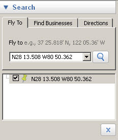
 In many of my entries I refer to "GPS Coords" - this is actually the latitude/longitude of the location I want you to look at. Your GPS unit's main function is to use satellites to determine where you are - recording the lat/long of the position. In order to see the place in Google Earth, you must have Google Earth desktop application available on your computer. If you do not have it or want to know more about it, see my writeup "How-To: Using Google Earth for Hiking" for more information. You can actually use the referenced lat/long in many applications, I'm just talking about Google Earth in this writeup.
 Here is what you do -
- Start Google Earth if not already started
- Check to insure the "Fly to" box is available on the left side of the screen - if not, hit "Ctrl-Alt-B" to show the sidebar
- Enter the Lat/Long you want to lookup in the "Fly to" box (can use Copy & Paste)
- Click on the magnifying glass icon to right of the "Fly to" box
No comments:
Post a Comment