The Bulldozer Canal is a manmade canal off the St Johns River. The flow of the St Johns River has been modified considerably in the area of Bulldozer Canal. Often in Florida’s past, Agricultural Engineers (I assume engineers) created canals and changed the character of the land by diverting water off the land and in directions they desired. Once what were wetlands became pastures, orange groves and homesteads. Bulldozer Canal is one of those major canals created to divert water to and from homesteader’s land. The canal these days looks nothing like what it did when it was first constructed and used. The main section off the St Johns is still passable at certain times of the year, but mainly it can only be used by airboats most of the year. I have been down there a few times in a small motorboat. One time we got right in, the other times we were either totally blocked by hydrias or the water was too shallow for the motor (did paddle at least part way down). You can see the sand piled high on one side from the original digging of the canal.
Cabins and Campsites
As you get about .7 of a mile down the canal from the St Johns River you will come to the first cabin still in existance on the canal. A little further west you will come to a second cabin. I have no idea how long those cabins have been there, but I suspect a very long time. Like everything, they have seen good days and bad days. During my visit in Feb 2012 I found them to be showing their age. The area around the cabins is kept clean and the cabins are also clean, I suspect by the local airboaters whom frequent the area. Both cabins are constructed on stilts to protect them from the high water which hits the area at times. As you proceed west on the canal a little further you will come across three separate campsites controlled (I wish maintained) by the SJRWMD. The campsites have signage which identifies them as “Bulldozer Canal Campsite”. Each campsite has at least one tent platform, as well as a fire area. Some benches and picnic tables are available, but not in the best of shape in Feb 2012. There is signage which states that they owned by the SJRWMD and only tents are allowed. The area is strictly a “first come, first serve” area. About 1.1 miles north as you follow one of the many airboat trails you will come to another SJRWMD campsite, this one is labeled “Spade Island Campsite”. Access to this campsite is from airboat trails from Bulldozer Canal or from the St Johns River directly. Depending on the water level, it might be an island (I have seen it covered with water) or just a dry hump amongst the cypress trees. I have visited this campsite a couple of times and each time I found the campsite to be fully occupied by hunters (no actual hunters, but all their gear). I suspect that this campsite is the center point for much of the hunting activity in the area. I doubt you could ever get a tenting spot in this campsite.
Surrounding Area
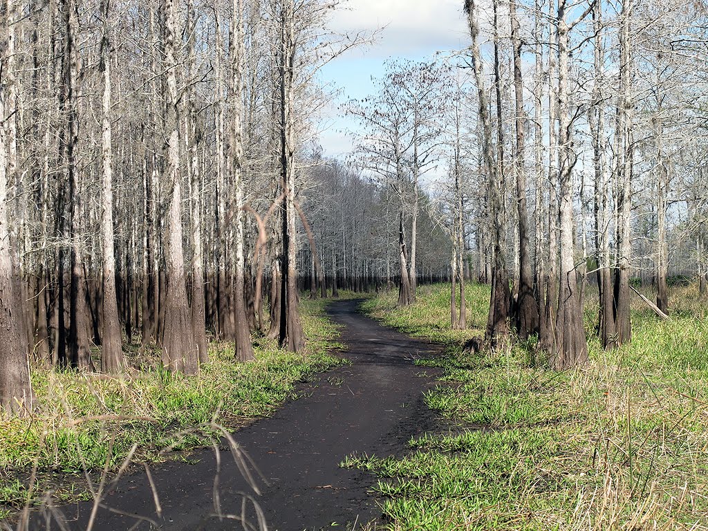
The area around Bulldozer Canal has seen a lot of activity over the years. The land north of it is crisscrossed with airboat trails. For those of you who don’t know what an airboat trail is, it is a path through the woods and fields wide enough for an airboat to pass through. The airboats use it even when it is dry (airboats are flat bottomed and pushed by air). Once a trail is established, it is maintained from that day forward by airboaters, they keep it clear of obstacles. If the water is high enough, even small motor boats can use them. During the dry season they can be walked and explored. The land north of Bulldozer Canal is I assume heavily hunted. I judge that by the number of hunter tree stands I have seen while wandering around. I made sure I wasn’t there during hunting season and I suggest you only elect to visit the area when there is no hunting activity. There are some beautiful cypress forests to explore. The distinct lines on the cypress trees from high water times is a wonderful site, truly picturesque. The land to the west belongs to Kempfer Ranch and is marked “no trespassing”. I suggest you don’t even consider crossing onto their land. The St Johns River is to the east and then there is the north. As you head further north from the canal you will most likely encounter water, even in dry times. When I wandered the area I kept encountering water and had to turn back, finally giving up after getting about 2 miles from the canal. The airboat trails are numerous and filled my day of exploring.
Wildlife and Wild Things
During February I didn’t see many wildflowers, just some small ones. I would hope that if you visited the area later in the spring that you might see more. I did come across some deer and signs that wild hogs frequented the area (I assume not during hunting season). The muddy spots revealed the tracks of raccoons and turkeys. I did almost step on a small water moccasin while walking an airboat trail. Even as small as it was, it still had a fierce desire to bite me. I think the cooler weather slowed it down. I have run across a few water moccasins during my exploring so I now wear sturdy snake-proof leg gaiters. There were a few songbirds fluttering around, as well as some wading birds near the canal.
Getting to the Canal
There is only one way I know of to get to Bulldozer Canal and the surrounding area and that is by boat. With an airboat you can get there at any time. With a motor boat, it would most likely have to be small and a very shallow runner. We launched the small motor boat we had from Camp Holly off RT192. It is about 7.5 miles from Camp Holly to the mouth of Bulldozer Canal. You should see a mess of gators wading birds along the river. I say a mess, but in reality, much less than what I would expect to see. I feel the river is dying and thus it no longer supports the game fish and wildlife which feed on the smaller fish that it once supported. You could try coming in from Three Forks Conservation Area by kayak or canoe, but I have no idea what kind of adventure that might be! The main river has shallow spots and also a couple of the lake areas you must cross, the open areas can get pretty rough. The channel can be hard to find, so plan ahead.
Summary
• The canal and surrounding area has an undocumented historical past (if anyone has information about that, please let me know)
• There are two full size cabins on the canal
• There are three SJRWMD campsites directly on the canal (Bulldozer Canal Campsites)
• There is a major campsite north of the canal (Spade Island Campsite)
• This is a major hunting area, so be aware of the hunting seasons – always wear bright colors
• Kempfer Deer Park Ranch owns the land to the west, so watch for their “no trespassing” signs
• This was an old homestead area, so if you’re lucky you might come across a piece of Florida history
• Airboats frequent the area at all times of the year, so if you hear one (very loud), make sure you are out of their way
• There are a number of airboat trails which crisscross the area
• According to topo maps this is wetlands, so expect some water just about all the time – during the wet season, the area is mainly a lake
Here are some of the GPS reference coordinates -
• Camp Holly Boat Launch - N28 05.089 W80 45.145
• Entrance to Bulldozer Canal from St Johns River - N27 59.857 W80 47.500
• Cabin Number 1 (other cabin right next to it) - N27 59.861 W80 48.220
• First SJRWMD Bulldozer Campsite - N27 59.870 W80 48.333
• SJRWMD Spade Island Campsite - N28 00.771 W80 48.369
• St Johns River Entrance to SJRWMD Spade Island Campsite - N28 01.833 W80 48.045
To view/download my wandering tracks - Click Here
My Tracks Map - Feb 2012 Visit -
Bulldozer Canal - Looking East -
Bulldozer Canal - Looking West -
One Of The Cabins On The Canal -
One Of The SJRWMD Campsites On The Canal -
Water Pump At SJRWMD Spade Island Campsite -
Airboat Trail Near Canal -
Airboat Trail Along The Cypress Trees -
Kempfer Ranch Property Line -
Border Line of Kempfer Ranch Property -
Airboat Trail During High Water -
Welcome – this website is about some of the Florida areas I’ve been to. It also provides information about GPS Units, Google Earth, Hiking Items, WIKILOC and other stuff. You will also find some pictures I’ve taken during my travels. Hopefully you will find it informative and helpful .............Tom Choma
Showing posts with label Places of Interest. Show all posts
Bull Creek Area Cemeteries
There are two very old cemeteries located in the Bull Creek area. Both cemeteries contain graves of local individuals whom passed on prior to the 1900’s. One cemetery is located within the boundaries of the Bull Creek WMA, while the other is on private property. There has been much confusion regarding the correct names of the cemeteries. Records illustrate that many people have believed the cemetery located within the Bull Creek WMA was the Bull Creek Cemetery. Some confusion may be attributed to the fact that each cemetery seems to be named after nearby creeks. The one in the Bull Creek WMA is near Crabgrass Creek; it is the Crabgrass Creek Cemetery (archive documents refer to it as Crab Grass Creek Cemetery). The other cemetery is near Bull Creek, thus it has been named Bull Creek Cemetery. I have visited both cemeteries. Archival documents for both of the cemeteries are available via the Internet. I was able to update online, the status and condition of both cemeteries. The Crabgrass Creek Cemetery is open to the public, while the Bull Creek Cemetery is on private property and is not open to the public. The Bull Creek Cemetery is actually part of a fenced in private property area, which is located within the very private Desert Ranch property. Both cemeteries are in very good shape, maintained in many cases by family members of those buried there. The names on the markers represent old Florida, in most cases the history of the families represented are hard to trace, another example of Florida’s historical heritage slipping away.
Map Showing Both Cemeteries (click to enlarge)
Crabgrass Creek Cemetery
Crabgrass Creek Cemetery is located within the boundaries of the Bull Creek WMA. Documents as well as local lore may refer to it as Crab Grass Creek Cemetery, Lanier Cemetery, Deer Park Cemetery or Sumner’s Place Cemetery. Many people believed it was the "Bull Creek Cemetery", but that is incorrect. You can get to it by hiking in from RT192 or drive in from the Bull Creek loop road if you wish, [and have a hardy 4 wheel drive vehicle]. There is a sign on the loop road that will direct you to the cemetery. Access to the loop road is from RT192; take Crabgrass Road into the Bull Creek WMA. If you elect to hike in from RT192, I have created a trail map which can be viewed at Bull Creek / Crab Grass Cemetery Hike. The hike is very nice, but always be aware that hunting in Bull Creek is quite popular. As of this writing there where 22 graves in Crab Grass Cemetery - oldest being laid to rest in 1883 to newest being laid to rest in 2000. There is a cyclone fence at the entrance side of the cemetery, with a wire fence around the rest of the cemetery. The grounds are partially grown in, with paths leading around the area. There are some very old stone markers, metal markers from the Bass Funeral Home, newer stone markers and some other unique markers. One gravesite has a metal fence surrounding it. It seems that family members have left different items near some of the gravesites to remember family members. The people found in this cemetery were truly pioneers in the area. Sad to write that their historical anecdotes seem to have gone with them. So often in Florida, it is very hard to trace historical items.
Here are the links to the documents about Crab Grass Creek Cemetery found in the Osceola County FlArchives Cemeteries Directory – you can click on either one to view them now -
Original Document –
http://files.usgwarchives.net/fl/osceola/cemetery/crabgrass.txt
May 31, 2007 Update -
http://files.usgwarchives.net/fl/osceola/cemeteries/crabgras2gcm.txt
The GPS Coords: N28 06.091 W80 56.811
Crabgrass Creek Cemetery Pictures (click to enlarge) -
Bull Creek Cemetery
The Bull Creek Cemetery is located south of Billy Lake, on the south side of Bull Creek. The only way I know of to get to that cemetery is from RT441. That area is private property so it is not available to the general public. I was granted permission to visit Bull Creek Cemetery in order to do an audit of the gravesites. There are at least 16 people buried in this cemetery. A number have gravestones, while many have just a metal marker from the Bass Funeral Home. From reading the grave stones and doing some research, the inhabitants buried here are of all ages, from infants to adults. According to some of the documentation, there are some unmarked graves also located in the cemetery. A simulated wrought iron fence surrounds the cemetery site; this fence looks relativity new. I have no idea what the original fence was, can only assume wrought iron. Outside the gate is a long wooden sign, with the names of the people buried in the cemetery burnt into it. When I was there, the sign had been pretty much worn down by Mother Nature, so the names were not legible. At least one of the gravestones has been replaced with a newer one. One grave had a civil war flag next to it. The designs of many hand carved stones were very interesting. The inhabitants found in this cemetery were truly pioneers in the area. Sad to write that their undocumented contributions to Florida’s history seem to have gone with them. So often in Florida, it is very hard to trace information on historical items.
Here are the links to the documents about Bull Creek Cemetery found in the Osceola County FlArchives Cemeteries Directory – you can click on either one to view them now -
Original Document –
http://files.usgwarchives.net/fl/osceola/cemetery/bullcrk.txt
February 7, 2008 Update -
http://files.usgwarchives.net/fl/osceola/cemeteries/bullcree6gcm.txt
GPS Coords: N27 59.462 W80 56.475
Bull Creek Cemetery pictures (click to enlarge) -
St Johns River Indian Mounds - From RT46 to Below RT520
There is a mess of mounds along the St Johns River below RT46, down to below RT520. A few of the mounds are named and can be found on Topo Maps. If you search the Internet you can find reference to them (little information, but reference). They are as far as I’ve been told, remnants of when the Indians were here in the area. I have visited most of them with a friend (The Boonie Man) by boat. Most all of them can only be easily accessed by boat. I am only trying here to give as much information as I have about the mounds I have visited - I believe history should be accurate, so the actual facts I leave to those who know.
Some of them are just mounds of dirt and common Florida plants and trees. Others have been used for camping and other activities. I’m told that all of them have been gone over to access their archaeological value. If you should spot anything that relates to the history of the mound, don't touch or take it - it is history and should be preserved! There are many archaeological agencies in the State of Florida who would like to know about any finds, so notify them of what you have seen. There really shouldn't be anything left on these mounds, they have been gone over very extensively by archaeologists.
If you know anything more about any of the mounds, please email me and/or post a comment about it.
Please note: I have been trying to find out where Baxter/Persimmion Mound is. I have created a website which will show you what I have found, you can Click Here or go to https://sites.google.com/site/baxterpersimmonmound/
Here is a list of the mounds, with my description and pictures. Click on the pictures to see a larger version of each. I have listed them in order of location from below RT46 to below RT520.
- Palmer-Taylor Mound - N28 41.883 W81 02.086.
This mound is a short distance from the Econlockhatchee River; about .23 miles walk from the river’s edge. This mound shows little sign of human activity. It does have a few spots where it looks like someone has been doing some digging. One or two things left by other people, but as I’ve said basically just a mound of Florida natural plants and trees.
Palmer-Taylor Mound
- Buzzard Roost Mound - N28 41.499 W81 01.736
This mound is on the south side of the Econlockhatchee River; about .21 miles walk from the river’s edge. It was a pretty wet walk the day we went to visit this mound. On this mound you will see signs of human activity, from an old charcoal grill to wooden planks nailed to trees. The mound is out in the open, with views in all directions. The cattle in the area had eaten the grass down pretty well all around the edge of the mound. The mound is made up mainly of palm trees and weeds.
Buzzard Roost Mound
- Noah Mound - N28 39.815 W81 01.188
Got closer to this mound today as the water level was much more favorable for getting to it with our boat. It is just a mound in the river covered with tall, thick weeds. Being that the weeds didn't look to great for digging through, we just did a spin around it and left. Later some local cattle may get to it and "weed it out", making it more accessible. I'm told there maybe a survey marker on it, but that has not been confirmed as of yet.
- Buck Point Mound - N28 39.184 W81 01.386
Made it out to see this mound the other day. It was quite a wet trip from the boat to dry land, so if you want to visit this mound you might expect that. Much to our surprise, the mound at the coords provided didn't really look like an Indian mound, it was pretty flat. The mound in front of it, nearer the river, actually looked like it could be the actual mound. It is very possible that maps are showing the wrong location for this mound (have seen that in other cases), so if you find out more, let me know.
- Heiffer Mound - N28 37.900 W81 00.353
This looks like just a mound of dirt with weeds on it. We where both surprised when we found that this was a named mound. I am assuming that under all that dirt is a pile of shells and Indian artifacts. You can see some shells and I did find a piece of looked like pottery at the river’s edge. During one visit there was an airboat flag atop it, but that was gone during the last visit. We meet some locals nearby and they informed us of a more colorful name they have for the mound.
Heiffer Mound
- Saddle Mound - N28 37.784 W81 00.503
This is a small mound in about .23 miles from Heiffer Mound. It is just a raised piece of land with some trees and weeds. It is a very pretty area, what there is of it. It is on the edge of what is currently (7/09) private property. We meet some Florida Forestry employees during one visit that informed us that this would be all public land in the not too distant future – that will be great! There is a USC&G Survey Marker located on the mound. Expect to encounter a lot of cow “paddies” when visiting this mound.
Saddle Mound
- Moccasin Mound - N28 37.833 W81 00.819
This is a small mound about .6 miles from Heiffer Mound. It is just a raised piece of land with some trees and weeds. It is a very pretty area, what there is of it. It is located within the Charles H. Bronson State Forest. You can get to it from the river or hiking in from the trailhead located at the end of Philipps Road (N28 35.513 W81 02.540).
Moccasin Mound
- Orange Mound - N28 35.900 W80 58.223
This mound does not appear on Topo Maps, but it does show up on many maps used to reference the area. It is a large mound, right on the edge of the river. I noticed from the boat that areas washed away revealed a shellfish shell base. We walked around it, as there are signs of human activity all through it. It is just about completely covered by palm and other trees.
Orange Mound
- Indian Fields Mound - N28 36.051 W80 56.703
This mound does not seem to appear on maps, I was shown it by a friend. It rises quite a bit above the land around it, with a huge oak tree near the top. I was told it is considered an historical place, but like so many things in Florida, information about it is hard to come by. It is located in the Salt Lake WMA. You can get to it by boat (kayak) or by land. If you don’t mind crossing a creek, the closest access point is from the observation tower gate on Hatbill Road (N28 37.853 W80 56.851). You can take the long way in from the main entrance to the Salt Lake WMA (N28 38.401 W80 53.397). The area around it has quite a few wild grapefruit and orange trees, as this once was an orchard quite a ways back.
Indian Fields Mound
- Paw Paw Mound – N28 31.254 W080 54.275
This one is a strange one as far as GPS coords are concerned. Topo maps show one spot, but as far as everyone who goes there, those are wrong - Topo map coords: N28 30.301 W80 54.271 – My coords: N28 31.254 W080 54.275
No idea what is causing this problem, but it is generally accepted that the actual mound is located at my coords.
This is a huge mound, right near the river. It is a major destination for airboaters, so expect to see some if you visit this mound. It has a variety of greenery, from oak trees, orange trees and palm trees. You will see a major human present affecting this mound. This is one that you can walk into quite easily from RT50. There is a USC&G Survey Marker located on the mound. I highly recommend a visit to this area; I have been here a number of times.
Paw Paw Mound
- Mulberry Mound - N28 21.801 W80 52.469
This a huge mound located just below RT520. As far as I know, boat access is the only way in, but I suspect that it could be accessed by land during certain times of the year. Again, being so close to the river you will encounter a large present of human activity – fires, trails and at times litter. There is at least one memorial to a passed airboater. It is pretty much covered with all kinds of trees, even some wild oranges. Orange trees where suppose to be left by the Spanish.
Mulberry Mound
Map Locations of Mounds (click to enlarge)
Well that is about it on the named mounds, like I mentioned earlier; if you have more information or know of anymore named mounds in the area of St Johns River I’ve covered, please leave a comment. You can see some of my boat trips detailed in WIKILOC. I ask you to please “take nothing but photos and leave nothing but footprints” when visiting any areas in the wild.
Subscribe to:
Posts (Atom)